Blog
Country Research Notes now feature population density maps
Our country Research Notes have been updated and now include population density maps. Population density is a crucial factor for most wireless services: it determines how many people can receive them and so the economic viability of a product or the cost of reaching most of the population. The population density maps, listed below, provide an insight into the different dynamics of using spectrum in different countries. They show in visual form…
Our country Research Notes have been updated and now include population density maps.
Population density is a crucial factor for most wireless services: it determines how many people can receive them and so the economic viability of a product or the cost of reaching most of the population.
The population density maps, listed below, provide an insight into the different dynamics of using spectrum in different countries.
They show in visual form the wide range of population density patterns around the world and the effect this has on the deployment of services.
The data is based on the leading global source. All country entries in the Spectrum Database now also include population density information.
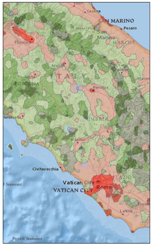
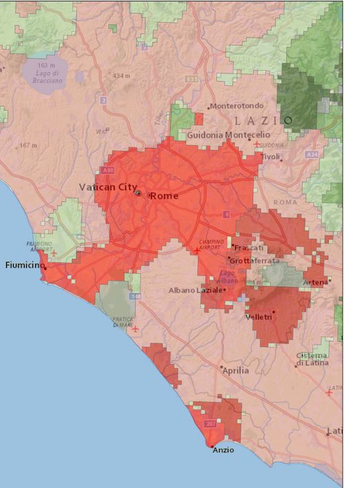
The maps are at an extremely high resolution, with the source data derived from 1 km² units. Click on the images to see examples from central Italy and the area around Rome.
| Map | Notable features |
| Australia | Huge areas of the country are almost uninhabited: 96% of landmass has 1 person per km² or less |
| Brazil | Over half the land mass is almost uninhabited |
| Canada | Population is concentrated near the US border and 60% of the land mass is uninhabited |
| China | 40% or 1.4 billion people live in intensively built-up areas covering 1% of country |
| France | 40% of population lives in intensively built-up areas: compared to only 19% in Germany |
| Germany | Very few sparsely populated areas: over 80% live in moderately built-up areas |
| India | 99% of the population live in cities or moderately built-up areas |
| Italy | Large uninhabited areas covering 17% of the country |
| Japan | 59% live in ‘intensively built-up areas but the North Island is more sparsely populated |
| South Korea | Densely populated: at least five people per km² across the whole country |
| Spain | 93% comprised of ‘sparsely populated’, ‘rural’ and ‘suburban’ areas where 30% of the population live |
| Sweden | 31% of the landmass is ‘almost uninhabited’ and houses just 1% of the population |
| UK | 75% of the population live in ‘dense urban’ areas which make up 7% of the land mass. |
The data illustrates how a dispersed population adds to the challenge of connecting developing countries.
For example, Laos has a similar population size to Hong Kong – around 6.8 million – but most live in rural or sparsely populated areas. To reach them you would need to cover 230,000 km². This is over 600 times bigger than the coverage required to serve about the same number of people in Hong Kong, where almost all its 7.3 million people live in the densely populated section, which accounts for 36% of the country – an area of 360 km².
Both the maps and our Spectrum Database display simplified forms of the underlying data. If you are interested in a more detailed picture please get in touch.
A new entry in our help section explains how the population data is sourced and used.
Experts talk spectrum.
Listen Now
Spectrum Research Service
- Dossiers new
- Benchmarking new
- Spectrum database
-
Research notes